As the planet warms and the fall wildfire risk lengthens, a NASA project involving Chapman researchers offers a first line of defense against the growing threat of mega-blazes.
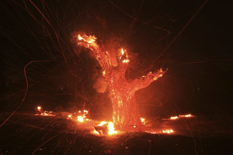
The tragic deaths of 19 “Hotshot” firefighters this summer in Arizona brought back to the headlines the extreme dangers of wildfires throughout the nation but especially in the West. By the end of July, almost 2.5 million acres had burned nationally. And that’s before California’s Rim fire erupted, consuming more than 250,000 acres in and around Yosemite National Park, costing better than $100 million to battle and at its peak involving 3,100 firefighters. Here’s the really ominous news: The traditional fire season is only now in full swing.
Experts point to the oscillating weather patterns — from torrential rains to long heat waves — that accompany global climate change as a cause for the recurring syndrome of wet
springs followed by dry summers and then fall fires. This year in California, the fire season actually started in May because ample winter rains fed a profusion of growth in brush, which dried out during a parched spring. Local governments, firefighting agencies and residents of fire-prone areas face a challenging fall as they search for long-term solutions to this cycle of fire danger.
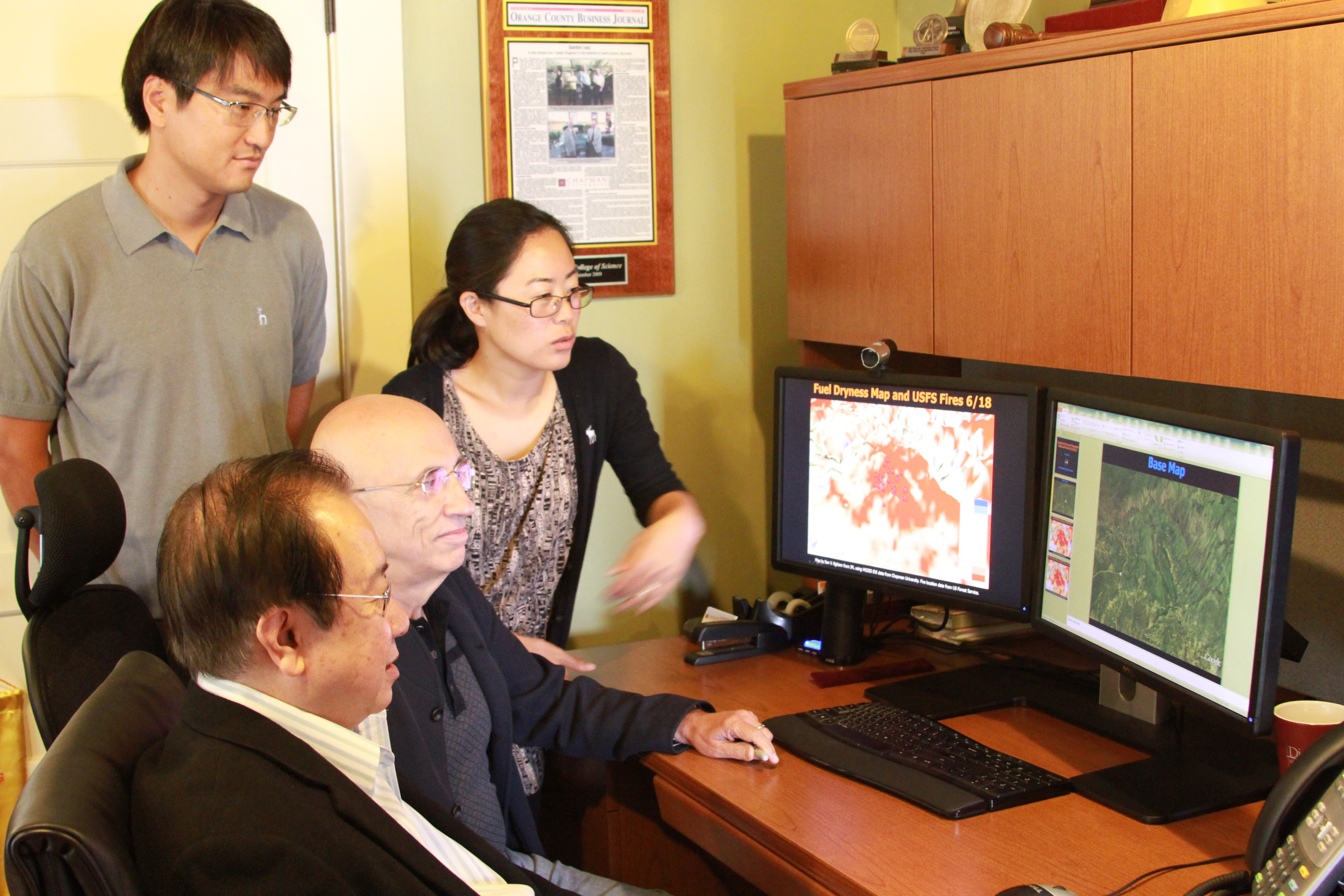
From left, Son Nghiem, Ph.D., of NASA’s Jet Propulsion Laboratory; Menas Kafatos, Ph.D., director of Chapman’s Center of Excellence in Earth Systems Modeling and Observations (CEESMO); and Boksoon Myong, Ph.D., staff research scientist at CEESMO, confer on data that help them assess fire danger.
One promising front-line defense is being created with the help of Chapman University researchers in the Center of Excellence in Earth Systems Modeling and Observations. Working with NASA’s Jet Propulsion Laboratory and the NOAA National Weather Service, Chapman scientists are using the university’s sophisticated XB Band Direct Broadcast antenna to directly receive key data from orbiting satellites. Co-principal investigator Menas Kafatos, Ph.D., of Chapman’s Schmid College of Science and Technology, and principal investigator Son Nghiem, Ph.D., of NASA’s Jet Propulsion Laboratory (JPL), lead a team of experts who are researching these data in a NASA-funded applied science project focusing on assessing fire danger before blazes start.This research project links with another — a climate and agriculture study funded by the National Science Foundation and the National Institute of Food and Agriculture, as wildfires
change local conditions affecting climate and ecosystems.
While research based on fire-weather interactions has been ongoing for decades, fire research related to climate change has only recently become a focus for scientists.
“This link is important, as it is related to long-term trends,” Nghiem said. “The data we receive several times daily here measure parameters crucial for fire-danger assessment, from the proliferation of fuel — the plants — to the moisture content of the plants and the soil. Based on all that, we can create a terrain map that shows where vegetation has dried out the most, and show it in near real time.”
“The satellite data we receive from NASA are free, but that doesn’t mean that everyone receives it in a timely manner,” Kafatos added. “Because Chapman has its own antenna, we get the data and process them within 15 minutes. With fires, it’s extremely important to have the most updated information, which we receive from NASA satellites in day and night passes.”
The antenna is good at tracking fast-moving fires as well as other hazards, such as floods, dust storms, smoke and pollution, Kafatos noted.
Nghiem emphasized that researchers’ role is not first response. “We’re looking at predicting where the risk of fire is greatest.” Once a fire has started, “it’s not currently possible to accurately predict the fire’s path in real time,” he added.
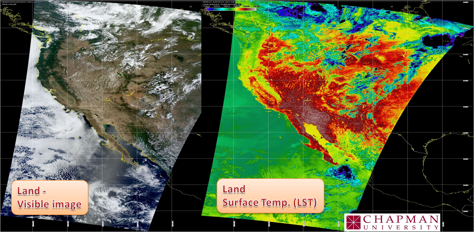
Satellite images are captured several times daily by Chapman’s XB Band Direct Broadcast antenna, right. With good pre-fire data, scientists can create a terrain map that shows where the hazard is greatest.
But with good pre-fire data, agencies such as those in Los Angeles, Ventura and Orange County, can make informed decisions about applying resources to mitigate the danger.
“We can see through these images whether vegetation is moist and alive or dead and dried out,” Kafatos said. “The fire agencies routinely send personnel to selected locations, cut and sample the vegetation and make their own measurements. That’s extremely labor-intensive work, and before the satellite data it was almost impossible to do it efficiently and frequently in every area.”
As the project progresses, the national agencies may post the reports online so the public can plan their own defense strategies. “If you live in an area where the fire danger is very high, you’d know to be on alert.” says Nghiem.
Plans for phase two of the project are waiting for approval. This phase would be three years long and build on initial lessons, Kafatos said. “We’ll be able to go into much more detail (on soil moisture), using the newest satellite that’s coming online next fall.”
But during the current fire season, news of the research is already spreading. When project scientists presented examples of satellite results to stakeholders at the Fire Summit in Diamond Bar, Calif., in May, the reaction was: “Wow, can we get those maps now?” Kafatos said.
“And that’s when I have to say, ‘Wait a minute, we’re just in phase one; but yes, you can see this is feasible and you can see the potential usage it has.’
“There’s a lot of excitement about the possibilities.”
>> READ MORE:
CBS documents
how science is fighting wildfires today; read more about these advances here. Check CA.gov for live updates on current wildfires in the state.
IMG: David McNew, Wesh.com